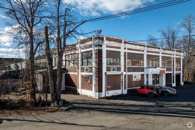
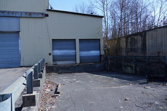
Property Record
665 N Avenue Ext, Dunellen, NJ 08812
Current Lease Availabilities
NEARBY LISTINGS FOR SALE OR LEASE
Property Detail
665 N Avenue Ext
New York-Jersey City-White Plains, NY-NJ
6.7AC
03-00049-0000-00036-01
Middlesex
Vacantlandnec
New Jersey
AE
36.1
34023C0028F
6.70 AC
2024
Western Rt 287
2025
Northern New Jersey
000300
DEMOGRAPHICS near 665 N Avenue Ext
1 Mile
3 Mile
5 Mile
2024 Total Population
15,777
102,601
241,476
2029 Population
15,461
101,669
239,368
Pop Growth 2024-2029
(2.00%)
(0.91%)
(0.87%)
Average Age
40
39
39
2024 Total Households
5,257
33,476
79,226
HH Growth 2024-2029
(2.13%)
(0.87%)
(0.88%)
Median Household Inc
$92,658
$99,656
$100,652
Avg Household Size
3.00
2.90
2.90
2024 Avg HH Vehicles
2.00
2.00
2.00
Median Home Value
$354,505
$368,719
$392,705
Median Year Built
1957
1963
1965
Nearby Places
Map Layers
Map Styles
 Street
 Aerial
- Restaurants
- Banks
- Shops
- Fitness
- Groceries
PUBLIC TRANSPORTATION
COMMUTER RAIL
Dunellen (Raritan Valley Line - NJ Transit Commuter Rail (NJ Transit))
DRIVE
WALK
Distance
Dunellen (Raritan Valley Line - NJ Transit Commuter Rail (NJ Transit))
4 min
20 min
1.0 mi
Bound Brook (Raritan Valley Line - NJ Transit Commuter Rail (NJ Transit))
DRIVE
WALK
Distance
Bound Brook (Raritan Valley Line - NJ Transit Commuter Rail (NJ Transit))
9 min
4.0 mi
AIRPORT
Newark Liberty International
DRIVE
WALK
Distance
Newark Liberty International
37 min
24.9 mi
Trenton Mercer
DRIVE
WALK
Distance
Trenton Mercer
59 min
37.7 mi
LaGuardia
DRIVE
WALK
Distance
LaGuardia
71 min
44.1 mi
Freight Ports
Maher Terminal
DRIVE
WALK
Distance
Maher Terminal
41 min
23.6 mi
Nearby Properties
Address
Land Use
TOTAL SIZE
Lot Size
Zoning
Address
Land Use
TOTAL SIZE
Lot Size
Zoning
27.46 AC
LI5
Address
Land Use
TOTAL SIZE
Lot Size
Zoning
31.49 AC
LI5
Address
Land Use
TOTAL SIZE
Lot Size
Zoning
24.12 AC
LI5
Address
Land Use
TOTAL SIZE
Lot Size
Zoning
24.62 AC
R20
Address
Land Use
TOTAL SIZE
Lot Size
Zoning
41.40 AC
LI5
Address
Land Use
TOTAL SIZE
Lot Size
Zoning
17.01 AC
RM
Address
Land Use
TOTAL SIZE
Lot Size
Zoning
64.99 AC
LI5
Address
Land Use
TOTAL SIZE
Lot Size
Zoning
17.64 AC
R10A
Address
Land Use
TOTAL SIZE
Lot Size
Zoning
27.51 AC
RM
Address
Land Use
TOTAL SIZE
Lot Size
Zoning
38.04 AC
RM
Address
Land Use
TOTAL SIZE
Lot Size
Zoning
12.57 AC
RM
Address
Land Use
TOTAL SIZE
Lot Size
Zoning
21.60 AC
LI5
Address
Land Use
TOTAL SIZE
Lot Size
Zoning
23.94 AC
M2
Address
Land Use
TOTAL SIZE
Lot Size
Zoning
48.79 AC
SC
Address
Land Use
TOTAL SIZE
Lot Size
Zoning
10.09 AC
Address
Land Use
TOTAL SIZE
Lot Size
Zoning
38.35 AC
ER
Address
Land Use
TOTAL SIZE
Lot Size
Zoning
32,704 SF
44.53 AC
LI5
Address
Land Use
TOTAL SIZE
Lot Size
Zoning
27.70 AC
Address
Land Use
TOTAL SIZE
Lot Size
Zoning
290,756 SF
19.78 AC
LI5
Address
Land Use
TOTAL SIZE
Lot Size
Zoning
230,022 SF
15.48 AC
LI5
Address
Land Use
TOTAL SIZE
Lot Size
Zoning
16.75 AC
LI5
Address
Land Use
TOTAL SIZE
Lot Size
Zoning
17.21 AC
L15
Address
Land Use
TOTAL SIZE
Lot Size
Zoning
4.05 AC
Address
Land Use
TOTAL SIZE
Lot Size
Zoning
275,431 SF
17.91 AC
LI5
Address
Land Use
TOTAL SIZE
Lot Size
Zoning
19.81 AC
M2
Address
Land Use
TOTAL SIZE
Lot Size
Zoning
16.21 AC
RM
Address
Land Use
TOTAL SIZE
Lot Size
Zoning
63.87 AC
LI5
Address
Land Use
TOTAL SIZE
Lot Size
Zoning
19.90 AC
IND
Address
Land Use
TOTAL SIZE
Lot Size
Zoning
254,656 SF
16.53 AC
LI5
Address
Land Use
TOTAL SIZE
Lot Size
Zoning
214,683 SF
13.38 AC
LI5
The World's #1 Commercial Real Estate Marketplace
Connect with us
© 2025 CoStar Group
The information above has been obtained from sources believed reliable. While we do not doubt its accuracy we have not verified it and make no guarantee, warranty or representation about it. It is your responsibility to independently confirm its accuracy and completeness. Any projections, opinions, assumptions, or estimates used are for example only and do not represent the current or future performance of the property. The value of this transaction to you depends on tax and other factors which should be evaluated by your tax, financial, and legal advisors. You and your advisors should conduct a careful, independent investigation of the property to determine to your satisfaction the suitability of the property for your needs.